|
In 1864,
the Queensland Department of Harbours and Rivers conducted the first official
survey of the Fitzroy River at the problematic Upper Flats. At that location in
particular, even small boats regularly became stranded at low tide and larger
vessels often came to grief on the shifting shoals. To improve navigation to Rockhampton,
Engineer of Roads Henry Plews recommended the construction of longitudinal rubble
stone 'training' walls (illustrated in red in the map below), accompanied by dredging.
The principle of river training was that, by narrowing the channel with artificial
banks or walls, the tidal flow would be concentrated sufficiently to scour the
bed clear of shoals. A river was considered properly trained when it achieved
and maintained adequate depths for shipping without the assistance of dredging.
However, due to the high cost of wall construction, dredging alone commenced in
1865. Unfortunately, the new channel repeatedly silted up to even shallower depths
than the natural channel. [Plews' plans for
Fitzroy.]
|
|
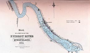 |
| Upper
flats, Fitzroy river, 1864, showing sandbanks and Plews' suggested training walls.
(QV&P, 1964) |
|
|