|
To the profound disappointment
of Rockhampton's civic and commercial pioneers, hopes of becoming a world-class
port on Australia's eastern seaboard did not come to fruition. Today, the only
shipping wharf is located at distant Port Alma, amid the saltpans and mudflats
on Raglan Creek just south of the Fitzroy mouth. (Its cargo now is largely salt
and explosives.) While other traces of port operations in Rockhampton have long
since disappeared, the legacy of decades of waterway engineering is a significant
alteration to the river's original form. Time and vegetation growth have largely
obliterated the natural contours of the Fitzroy, but modern users of the river
are familiar with the stone walls which, in various states of repair, line some
30 km of banks below Rockhampton. The best preserved examples are 'The Stone Wall'
opposite the Nerimbera slipway and Satellite Wall farther downstream. These walls
were integral in changing the shape nature carved on the landscape with the Fitzroy.
[River banks and walls.]
Photos by B.Webster 2/2002
|
|
|
|
|
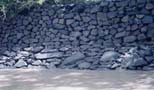
'The
Stone Wall at low tide, opposite the Nerimbera slipway, Fitzroy River, Central
Queensland. Originally constructed in 1875, the 4km wall was dry-stone faced in
the 1930s. |
|
|
|
|
|
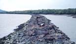
Satellite
Wall at low tide, Fitzroy River, constructed between 1896 and 1916, the 5km
rubble-stone wall closed off Alligator Passage and Satellite Channel. |
|
|
|